|
gm. Nowy Staw, pow. malborski, woj. pomorskie
Until 1945 Tansee (Schrőtter), Tanse (Endersch), Tausche (Gotha)Until 1945 Tansee (Schrőtter), Tanse (Endersch), Tausche (Gotha)

The village was established in the pre-Teutonic Order period. The charter was renewed under the Chełmno law in 1318 and 1321 by Werner von Orseln. The village had 60 (62 in 1318) włókas of land. Documents from 1318 mention a parish priest. In the 17th century, the village had a half-timbered church with a wooden tower, which in 1823 was replaced by a church of the same structure. The building had a rectangular layout, a tower situated in a nave, and a presbytery sectioned off by side spaces. The building was taken down after 1945. Lutherans appeared in Świerki in the 16th century. A Lutheran church was mentioned in 1603 (renovated in 1708). At the time, the building was in poor condition and was replaced in 1798 by a new, octagonal church, which was taken over by Catholics after 1945. Village layout - an oval village with a centrally located former Lutheran church surrounded by a cemetery; the second cemetery is located in the southwestern section of the village; large farms are situated on external sides of streets - 3 on the western side and 3 on the eastern side. The cultural landscape has partially survived with detectable spatial layout, a half-timbered, octagonal Lutheran church from 1798 (present day St. Bartolemeu Catholic church), an old cemetery with old linden trees, a (cleaned) old Catholic cemetery (again functioning) with several gravestones, road system, remains of a narrow-gauge railway in the southern section of the village, and traditional homesteads. An old half-timbered Catholic church with a half-timbered tower was taken down after 1945. Old buildings are being modified or replaced preserving the traditional localization. Large new villas with low, wide broach roofs are being constructed. Only 2 arcaded houses have survived out of 5 such buildings that existed until 1945. One of them built by Conrad Fröse belonged to the Cornelses family.
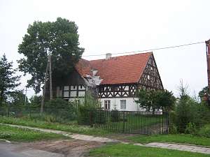 No. 31 is an arcaded house from 1744 erected by Georg Pöck.
The building belonged to Gustaw Dőhring and then, since 1776 to the
Schopnauer family. The house probably dates from the 1st half of the 17th
century; it was modified in the 19th century and renovated ca. 1910.
It is situated in the southern section of the village, on the eastern side
of the road. The building has a brick ground floor, half-timbered first
floor, a rafter - two-collar beam (partially queen post - purlin) roof
structure, and pantile roofing. The arcade has been taken down. The
building has a traditional layout with a gable arcade, a hallway along the
southern wall, a centrally located black kitchen, and a row of rooms on
its northern side. Two rooms were added later on the southern side and 2
on the northern side (separated by a hallway opened on both sides).
Another room was sectioned off in the southwestern corner of the hallway.
The southern elevation has 3 axes (two levels) and a
half-timbered, two-level gable. The western elevation has 9 axes with a
5-axial upper, protruding section and an entrance located centrally
between two windows. No. 31 is an arcaded house from 1744 erected by Georg Pöck.
The building belonged to Gustaw Dőhring and then, since 1776 to the
Schopnauer family. The house probably dates from the 1st half of the 17th
century; it was modified in the 19th century and renovated ca. 1910.
It is situated in the southern section of the village, on the eastern side
of the road. The building has a brick ground floor, half-timbered first
floor, a rafter - two-collar beam (partially queen post - purlin) roof
structure, and pantile roofing. The arcade has been taken down. The
building has a traditional layout with a gable arcade, a hallway along the
southern wall, a centrally located black kitchen, and a row of rooms on
its northern side. Two rooms were added later on the southern side and 2
on the northern side (separated by a hallway opened on both sides).
Another room was sectioned off in the southwestern corner of the hallway.
The southern elevation has 3 axes (two levels) and a
half-timbered, two-level gable. The western elevation has 9 axes with a
5-axial upper, protruding section and an entrance located centrally
between two windows.
 No. 49 is an arcaded house situated in the
western section of the village. Initially, it belonged to Paul Schroeder
and later to Cornelsen. The building was erected in 1843 on a foundation
of an earlier house (modified in 1866 and at the end of the 19th century).
It has a log structure, a vertically boarded, high pointing sill, and a
half-timbered arcade supported by wooden Tuscan columns and half-timbered
"anty". The southern gable elevation has 3 axes and a 2-level gable with 4
axes in the lower level, 2 windows enclosed by rectangular skylights
topped by segmented arches, and a doubled form of the skylight above. The
eastern elevation 7 axes, small windows bound by segmented arches in the
pointing sill, a 2 window extension, an arcade in 3 central axes, and a
central entrance. Window and door frames, architectural details, and
fretwork decoration in gables have survived. No. 49 is an arcaded house situated in the
western section of the village. Initially, it belonged to Paul Schroeder
and later to Cornelsen. The building was erected in 1843 on a foundation
of an earlier house (modified in 1866 and at the end of the 19th century).
It has a log structure, a vertically boarded, high pointing sill, and a
half-timbered arcade supported by wooden Tuscan columns and half-timbered
"anty". The southern gable elevation has 3 axes and a 2-level gable with 4
axes in the lower level, 2 windows enclosed by rectangular skylights
topped by segmented arches, and a doubled form of the skylight above. The
eastern elevation 7 axes, small windows bound by segmented arches in the
pointing sill, a 2 window extension, an arcade in 3 central axes, and a
central entrance. Window and door frames, architectural details, and
fretwork decoration in gables have survived.
The Catholic
cemetery is located in the southwestern section of the village. It has a
layout of an irregular polygon layout encircled by ashes, limes, and maple
trees. There are remains of a church destroyed after 1945 and several
gravestones with Dutch names: stalls of Justyna and Jakub Claasen from
1863 and Gertruda Claasen from 1882 and a cast iron cross of Martin
Schroeder from 1863.
Schmid, s.305-319, Lipińska, t. III, poz. 201; AG IV
|
)