|
gm. Nowy Staw, pow. malborski, woj. pomorskie
Until 1945 Tra(a)lau TK (Gotha, Endersch, Schrőtter)
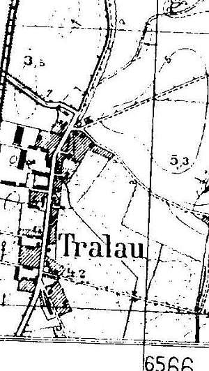
The village was founded in 1399 or 1470. In the 18th century, 7 Mennonite families lived in the village: Hage, Peters, Dercks, Gnohs, Claasen, Epp, and Reger. The sources from 1776 mentioned the surnames: Dircksen, Epp, Claasen, and Regehr. In 1820, the village had 12 Mennonites. In 1885, the village had 512 ha, 21 houses, 257 Catholics and Lutherans, and 36 Mennonites. In 1912, there were 7 Mennonite families, and in 1936 - 10 families. Village layout - linear village with buildings on both sides of the Malbork - Nowy Staw road; there are 5 large farms in the western section of the village, 1 in the eastern section, and a colony located to the east of the village . The cultural landscape of the village is well preserved with detectable spatial layout, remains of 3 Dutch homesteads: no. 2, 7 (masonry buildings from the beginning of the 20th century), and 9, a large homestead from the beginning of the 20th century with a regional-style building from the 1st quarter of the 20th century, several masonry buildings from the 1st quarter of the 20th century, and 2 detached wooden buildings from the mid 1800s. The contemporary buildings of the homestead no. 17 preserved its Winkelhoff layout. Rows of old trees and coble stone streets have also survived. Old trees - mainly limes, but also oaks, maples, and ashes - line the road and a village street.
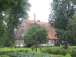 No. 2 is a Dutch homestead of the longitudinal type situated
in the southern section of the village, on the eastern side of the road,
facing it with its ridge (a cowshed and a barn have been demolished). The
house dates from the end of the 18th century. It has a log structure with
covered quoins, a vertically boarded gable, a high ceramic roof, and a
wooden porch (western side). The building has an original interior layout
with the large room in the northeastern corner, a centrally located black
kitchen, and a large farming section (southern side) separated from the
residential section (northern side) by a hallway. No. 2 is a Dutch homestead of the longitudinal type situated
in the southern section of the village, on the eastern side of the road,
facing it with its ridge (a cowshed and a barn have been demolished). The
house dates from the end of the 18th century. It has a log structure with
covered quoins, a vertically boarded gable, a high ceramic roof, and a
wooden porch (western side). The building has an original interior layout
with the large room in the northeastern corner, a centrally located black
kitchen, and a large farming section (southern side) separated from the
residential section (northern side) by a hallway.
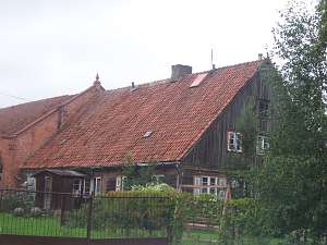 No. 9 is a
longitudinal Dutch homestead situated in the central section of the
village, on the western side of the road, facing it with its ridge. A
cowshed (the same height as the house) is separated from the house by a
high fire wall (a barn has been demolished). The house dates from the 1st
quarter of the 19th century and has a log structure covered by boards
imitating Tuscan pilaster, a vertically boarded gable, a high ceramic
roof, and a wooden porch (southern side) The original interior has been
preserved with the large room in the southeastern corner, a centrally
located black kitchen, and a large farming section (southern side)
separated from the residential section (northern side) by a hallway. No. 9 is a
longitudinal Dutch homestead situated in the central section of the
village, on the western side of the road, facing it with its ridge. A
cowshed (the same height as the house) is separated from the house by a
high fire wall (a barn has been demolished). The house dates from the 1st
quarter of the 19th century and has a log structure covered by boards
imitating Tuscan pilaster, a vertically boarded gable, a high ceramic
roof, and a wooden porch (southern side) The original interior has been
preserved with the large room in the southeastern corner, a centrally
located black kitchen, and a large farming section (southern side)
separated from the residential section (northern side) by a hallway.
SGKP, t. XII, s. 445; Penner, s.85; ML t.IV, s. 351, Lipińska, t.III, poz.202; AG BF.
|
)