|
gm. Stegna, pow. nowodworski, woj. pomorskie
Until 1945 Tiegenort (Endersch, Schrötter) Tiger werde (Gotha)
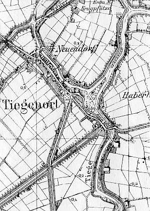
The village was established in 1349 by Henryk Dusemer. In the 17th century, the village was included in the colonization campaign. In 1820, the village had 315 residents, including 24 Mennonites. In 1885, the village had 231 włókas, 43 houses, 334 Catholics and Lutherans, and 15 Mennonites. Village layout - partially, a flood bank linear village transformed into a two-sided linear village along the Nowy Dwór - Stegna road and a water linear village in the northern section by the local tributary, by the Stara Tuga flood bank; the village of Neuendorf was located on the northern side; there is a Lutheran church and a modern church at the eastern end of the village. The cultural landscape is in good condition. The older section, Neuendorf is in decline - construction of modern buildings. The village is densely built up and includes 21 wooden houses from the 2nd half of the 19th century and brick houses from the beginning of the 20th century. Four Dutch homesteads (heavily modified) and a system of draining ditches and polders have survived. .
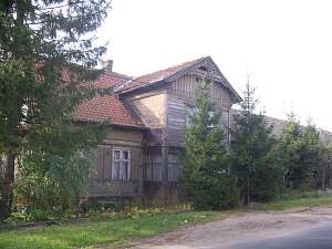
 No. 10 is a longitudinal Dutch homestead situated in the
eastern section of the village (Tujsk II), on the southern side of a
street, facing it with its ridge. A cowshed and a barn are slightly higher
and are separated from the residential section by a fire wall. The house
dates from the 3rd quarter of the 19th century. A barn gate with S-shaped
slats has survived. No. 10 is a longitudinal Dutch homestead situated in the
eastern section of the village (Tujsk II), on the southern side of a
street, facing it with its ridge. A cowshed and a barn are slightly higher
and are separated from the residential section by a fire wall. The house
dates from the 3rd quarter of the 19th century. A barn gate with S-shaped
slats has survived.
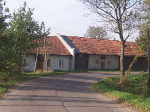
 A building without a number is a house from
an (probably) angular Dutch homestead situated in the eastern section of
the village, on the southern side of the local road, facing it with its
ridge (farming buildings - replaced). It dates from the mid 1800s and has
a log structure with quoins covered by boards imitating Tuscan pilaster, a
vertically boarded gable, a wooden porch in front of the northern
entrance, and asbestos tile roofing. The gable elevation has 3 axes, a
two-level gable with a window enclosed by narrow skylights and a
semicircular skylight above. The southern elevation has 6 axes with an
entrance located between two windows in the 3rd axis from the
east. A building without a number is a house from
an (probably) angular Dutch homestead situated in the eastern section of
the village, on the southern side of the local road, facing it with its
ridge (farming buildings - replaced). It dates from the mid 1800s and has
a log structure with quoins covered by boards imitating Tuscan pilaster, a
vertically boarded gable, a wooden porch in front of the northern
entrance, and asbestos tile roofing. The gable elevation has 3 axes, a
two-level gable with a window enclosed by narrow skylights and a
semicircular skylight above. The southern elevation has 6 axes with an
entrance located between two windows in the 3rd axis from the
east.
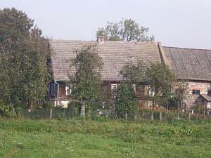
 No. 70 is a house from a (probably) angular Dutch homestead
situated in the northern section of the village between a street and
canal, facing it with its ridge. A cowshed (plastered) is separated from
the house by a low fire wall. A barn has been taken down. The house dates
from the end of the 18th or beginning of the 19th century and has a
horizontally boarded wooden structure, a vertically boarded gable, a
wooden porch in front of the entrance (east side), a rafter - two-collar
beam roof structure supported by a protruding top plate resting on notched
ceiling beams, and pantile roofing. The gable elevation has 3 axes, a
4-axial gable with two windows enclosed by small windows topped by a
reverse ogee arches and a square skylight formed by a doubled form of the
side windows above. No. 70 is a house from a (probably) angular Dutch homestead
situated in the northern section of the village between a street and
canal, facing it with its ridge. A cowshed (plastered) is separated from
the house by a low fire wall. A barn has been taken down. The house dates
from the end of the 18th or beginning of the 19th century and has a
horizontally boarded wooden structure, a vertically boarded gable, a
wooden porch in front of the entrance (east side), a rafter - two-collar
beam roof structure supported by a protruding top plate resting on notched
ceiling beams, and pantile roofing. The gable elevation has 3 axes, a
4-axial gable with two windows enclosed by small windows topped by a
reverse ogee arches and a square skylight formed by a doubled form of the
side windows above.
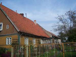
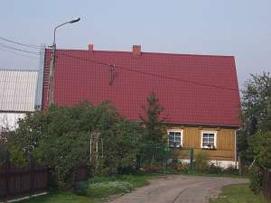
 No. 38 is a longitudinal Dutch homestead
situated in the western section of the village, on the southern side of
the road, facing it with its ridge. Farming buildings are modern and are
separated from the house by a high fire wall. The house dates from the 3rd
quarter of the 19th century. It is a wooden, single-storey building with a
low pointing sill, glazed-in arcade, and an extension in the northern roof
slope supported by 4 wooden posts. The building has a log structure with
covered quoins, a vertically boarded gable, a queen post - purlin roof
structure, and pantile roofing. No. 38 is a longitudinal Dutch homestead
situated in the western section of the village, on the southern side of
the road, facing it with its ridge. Farming buildings are modern and are
separated from the house by a high fire wall. The house dates from the 3rd
quarter of the 19th century. It is a wooden, single-storey building with a
low pointing sill, glazed-in arcade, and an extension in the northern roof
slope supported by 4 wooden posts. The building has a log structure with
covered quoins, a vertically boarded gable, a queen post - purlin roof
structure, and pantile roofing.
 No. 50 is a house from a
(probably) angular Dutch homestead situated at the western end of the
village, facing the main road with its gable. The building dates from the
mid 1800s. It is a wooden, single-storey building with a high roof covered
by sheet metal imitating tiles. The gable elevation has 3 axes and a
2-axial gable. The eastern elevation has 6 axes with an entrance and a
wooden porch in the 3rd axis from the west. No. 50 is a house from a
(probably) angular Dutch homestead situated at the western end of the
village, facing the main road with its gable. The building dates from the
mid 1800s. It is a wooden, single-storey building with a high roof covered
by sheet metal imitating tiles. The gable elevation has 3 axes and a
2-axial gable. The eastern elevation has 6 axes with an entrance and a
wooden porch in the 3rd axis from the west.
SGKP, t. XII, s. 337;, Lipińska, t. III, poz.257; AG.
|
)