|
gm. Elbląg, pow. elbląski, woj. warmińsko - mazurskie
Until 1945 Ellerwald Erste Trift TK (Endersch, Schrőtter), Herretrift.
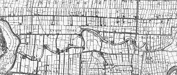
In the Teutonic Knight period, the area of the present-day villages of Adamowo, Kazimierzowo, Janowo, Władysławowo, and Helenowo was covered by marshes, which after digging the Kanał Jagielloński in 1495 were converted into meadows that belonged to Stare Miasto. The development of the meadows began in 1563 when 4 causeways were built; the areas adjacent to these causeways reflected the ownership structure of Stare Miasto in Elbląg. Four hundred thirty five plots were allocated, which corresponded to each tenement house in the town. In order to develop the area, the burghers invited Dutch settlers. The Mennonites who lived in the area belonged to the Ellerwald-Elbing community. In 1776, the following Mennonite surnames were recorded as residents of the Ellerwald villages: Barg, von Bergen, Block, Brand, Brandy, Dircksen, Dick, Sens, Essau, von Riesen, Guenther, Harm, Hiebert, Isaac, Jantzen, Kieler, Kroacker, Loewen, Martens, Neufeldt, Penner, Rempel, Sawatsky, Thiessen, Thimm, Toews, Weis, Wieb, Wiebe, Wiele, Wiens, and Wilmp. In 1921, the area was inhabited by 736 Mennonites. In 1820, Władysławowo had 168 residents of whom 70 were Mennonites. At the beginning of the 20th century, the village had 588 ha and 280 residents. The village layout - a marsh row village. The cultural landscape is in decline. In 1986, 9 out of 17 original homesteads still were present. A field layout, a system of draining canals with willow rows have survived.
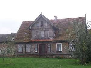 No. 7 is a longitudinal Dutch homestead located on the
southern side of the road, facing it with the ridge. The house was erected
in the 1st half of the 19th century and modified in 1892. Until 1945, the
house belonged to Herman Nikiel. It has a log structure with quoins
covered by boards imitating Tuscan pilaster, a stone foundation, a log
attic room in the northern roof slope, vertically boarded gables, and a
wooden, queen post - purlin roof structure resting on a top plate and
ceiling beams. The interior has a 2-bay layout with uneven bays and a
divided (later) large room in the northwestern corner, a black kitchen in
the large room corner, two separate hallways - a main square hallway and a
rectangular utility hallway with a passage leading to a cowshed and
separating two spaces. The gable elevation has 3 axes, a 4-axial gable,
two windows enclosed by two smaller windows with segmented arches and a
small window with a segmented arch above. There is an attic room
(originally with a shallow balcony) with three windows with segmented
arches. The building has rich architectural detail: window frames, purlin
supports, notched ends of purlin and ceiling beams, carved ends of
planking, and onion shape of a pazdur. A cowshed and a barn have been
demolished. No. 7 is a longitudinal Dutch homestead located on the
southern side of the road, facing it with the ridge. The house was erected
in the 1st half of the 19th century and modified in 1892. Until 1945, the
house belonged to Herman Nikiel. It has a log structure with quoins
covered by boards imitating Tuscan pilaster, a stone foundation, a log
attic room in the northern roof slope, vertically boarded gables, and a
wooden, queen post - purlin roof structure resting on a top plate and
ceiling beams. The interior has a 2-bay layout with uneven bays and a
divided (later) large room in the northwestern corner, a black kitchen in
the large room corner, two separate hallways - a main square hallway and a
rectangular utility hallway with a passage leading to a cowshed and
separating two spaces. The gable elevation has 3 axes, a 4-axial gable,
two windows enclosed by two smaller windows with segmented arches and a
small window with a segmented arch above. There is an attic room
(originally with a shallow balcony) with three windows with segmented
arches. The building has rich architectural detail: window frames, purlin
supports, notched ends of purlin and ceiling beams, carved ends of
planking, and onion shape of a pazdur. A cowshed and a barn have been
demolished.
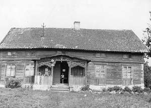
 No. 15 is a longitudinal Dutch homestead situated on
the northern side of the road, facing it with the ridge. The house dates
from the 1830s and until 1945 belonged to Gustaw Hebe. It has a log
structure with quoins covered by boards imitating Tuscan pilaster, a stone
foundation, and a wooden, rafter - collar beam roof structure. The
interior has a 2-bay layout with uneven bays, the square large room in the
southwestern corner, a black kitchen in the large room bay, and an
L-shaped, bipartite hallway, which separates an apartment from a cowshed
with a staircase by the northwestern corner. The gable elevation has 2
axes and a single-axial gable. The frontal elevation has 4 axes with an
entrance in the northern axis. A cowshed was added at the beginning of the
20th century. No. 15 is a longitudinal Dutch homestead situated on
the northern side of the road, facing it with the ridge. The house dates
from the 1830s and until 1945 belonged to Gustaw Hebe. It has a log
structure with quoins covered by boards imitating Tuscan pilaster, a stone
foundation, and a wooden, rafter - collar beam roof structure. The
interior has a 2-bay layout with uneven bays, the square large room in the
southwestern corner, a black kitchen in the large room bay, and an
L-shaped, bipartite hallway, which separates an apartment from a cowshed
with a staircase by the northwestern corner. The gable elevation has 2
axes and a single-axial gable. The frontal elevation has 4 axes with an
entrance in the northern axis. A cowshed was added at the beginning of the
20th century.
 No. 19 is a longitudinal Dutch homestead situated
on the northern side of the road, facing it with the ridge. The house was
erected in the 1830s and modified after 1850s. Until 1945, it belonged to
Alice Wedekind. It has a log structure with quoins covered by boards
imitating Tuscan pilaster, a brick foundation, a wooden, queen
post/purlin/two-collar beam roof structure, and a half-timbered (upper
section), vertically boarded gable. The interior has a 2-bay layout with
uneven bays, the square large room in the southwestern corner, a black
kitchen in the large room bay, and two separate hallways: a bipartite,
C-shaped hallway with a black kitchen and a long, narrow hallway with a
row of 4 doors leading to a cowshed passage, to an utility room, and to
the stairs. The gable elevation has 3 axes and a 2-axial gable with a
semicircular window. The frontal elevation has 7 axes and an entrance with
a porch decorated with fretwork (5 axes in the pointing sill). Windows
have board frames with window sills. A cowshed and a barn have been taken
down. No. 19 is a longitudinal Dutch homestead situated
on the northern side of the road, facing it with the ridge. The house was
erected in the 1830s and modified after 1850s. Until 1945, it belonged to
Alice Wedekind. It has a log structure with quoins covered by boards
imitating Tuscan pilaster, a brick foundation, a wooden, queen
post/purlin/two-collar beam roof structure, and a half-timbered (upper
section), vertically boarded gable. The interior has a 2-bay layout with
uneven bays, the square large room in the southwestern corner, a black
kitchen in the large room bay, and two separate hallways: a bipartite,
C-shaped hallway with a black kitchen and a long, narrow hallway with a
row of 4 doors leading to a cowshed passage, to an utility room, and to
the stairs. The gable elevation has 3 axes and a 2-axial gable with a
semicircular window. The frontal elevation has 7 axes and an entrance with
a porch decorated with fretwork (5 axes in the pointing sill). Windows
have board frames with window sills. A cowshed and a barn have been taken
down.
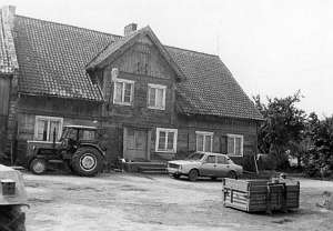
 No. 21 is a house from a longitudinal Dutch homestead
situated on the northern side of the road, facing it with its ridge. It
was erected at the beginning of the 19th century. It has a
plastered, log structure with wooden, a queen post - purlin, two-collar
beam roof structure, and a pent-roofed attic rooms in the northern and
southern roof slopes. The interior has a 2-bay layout with uneven bays, a
rectangular large room in the southeastern corner, a black kitchen in the
large room bay, and a C-shaped hallway divided into 3 sections and located
by the western wall. The gable elevation has 2 axes, a 2-level gable -
originally 3-axial in the lower section - a wide window with two narrow
windows on the sides, and a triangular skylight above. The frontal
elevation has 5 axes, an entrance with a porch in the 3rd axis, and an
attic room with 4 small windows (semicircular tops) separated by cannelled
pilasters above the porch. No. 21 is a house from a longitudinal Dutch homestead
situated on the northern side of the road, facing it with its ridge. It
was erected at the beginning of the 19th century. It has a
plastered, log structure with wooden, a queen post - purlin, two-collar
beam roof structure, and a pent-roofed attic rooms in the northern and
southern roof slopes. The interior has a 2-bay layout with uneven bays, a
rectangular large room in the southeastern corner, a black kitchen in the
large room bay, and a C-shaped hallway divided into 3 sections and located
by the western wall. The gable elevation has 2 axes, a 2-level gable -
originally 3-axial in the lower section - a wide window with two narrow
windows on the sides, and a triangular skylight above. The frontal
elevation has 5 axes, an entrance with a porch in the 3rd axis, and an
attic room with 4 small windows (semicircular tops) separated by cannelled
pilasters above the porch.
 No. 23 is an angular Dutch homestead
located on the southern side of the road, facing it with the ridge. The
house was erected in the 1st half of the 19th century and modified at the
end of that century. It has a log structure with quoins covered by boards,
a vertically boarded pointing sill and gable, a brick foundation, a
wooden, queen post - purlin roof structure with angle braces resting on a
pointing sill, and a log attic room in the northern roof slope. The
interior has a 2-bay layout with similar bays, the large room in the
northwestern corner, a central black kitchen, and separate hallways with a
row of doors in the eastern wall of the utility hallway leading to a
cowshed passage, to stairs, and to a utility room. The gable elevation has
3 axes, a 4-axial gable, two windows enclosed by triangular skylights, and
a semicircular skylight above. The building is decorated with a grid
located between wind ties and a pazdur. The frontal elevation has 5 axes,
an entrance in the 2nd axis from the east, a 2-axial attic room with a
semicircular skylight in the gable, and decorative doors. No. 23 is an angular Dutch homestead
located on the southern side of the road, facing it with the ridge. The
house was erected in the 1st half of the 19th century and modified at the
end of that century. It has a log structure with quoins covered by boards,
a vertically boarded pointing sill and gable, a brick foundation, a
wooden, queen post - purlin roof structure with angle braces resting on a
pointing sill, and a log attic room in the northern roof slope. The
interior has a 2-bay layout with similar bays, the large room in the
northwestern corner, a central black kitchen, and separate hallways with a
row of doors in the eastern wall of the utility hallway leading to a
cowshed passage, to stairs, and to a utility room. The gable elevation has
3 axes, a 4-axial gable, two windows enclosed by triangular skylights, and
a semicircular skylight above. The building is decorated with a grid
located between wind ties and a pazdur. The frontal elevation has 5 axes,
an entrance in the 2nd axis from the east, a 2-axial attic room with a
semicircular skylight in the gable, and decorative doors.
Kerstan, s. 199 - 209; ML, t. I, s. 548 - 550; AG IV, BF, Lipińska, t. III, poz. 73
|
)