|
gm. Markusy, pow. elbląski, woj. warmińsko - mazurskie
Until 1945 Hohenwalde TK (Endersch, Schrötter) Schwansdorf (Gotha),
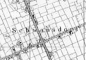
Until the 14th century, the area of Krzewsk was under water. In 1631, Dutch settlers began to develop the terrain. The sources form 1776 mentioned the following Mennonites: Albrecht, Allert, Dau, Erben, Funck, Goertzen, Gruntu, Harms, Horn, Hein, Jantz, Jantzen, Martens, Niese, Philipsen, Siebert, Tetzlaff, and Wall. In 1820, the village had 258 residents, including 88 Mennonites. In 1885, the village had 721 ha of land, 52 houses, and 323 residents, including 99 Mennonites. Village layout - Waldhufendorf village on both sides of the Elbląg - Markusy road running on a causeway in a north-south line, and along a side road to Jezioro. The cultural landscape includes longitudinal and angular Dutch homesteads on terpy (usually, facing a road with their gables). Currently, the cultural landscape is in decline. Dutch homesteads are disappearing with houses being their most durable elements. New buildings have nothing in common with the historical architecture.
In 1980s, the Dutch buildings were quite numerous - ca. 30-32 in 40 identified homesteads. This number has fallen by over 50%. The majority of historical buildings date from the 2nd half of the 19th century. They include ca. 25 wooden and bricked houses. The arcaded house no. 3 has not survived. A field layout on eastern and western sides of roads and a system of canals and ditches are well detectable. Fragments of vegetation surrounding homesteads have also survived. Trees lining the roads have been cut down, but the rows of willows along the drainage canals have survived.
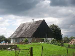 No. 2, No. No. 48 is a house from a Dutch homestead of the
angular type (farm building have been demolished). It dates from the 1st
quarter of the 18th century and is situated on a terpa, on the southern
side of the road to Jezioro, facing it with its gable. It has a brick
underpinning, a plastered log structure, a rafter - two-collar beam roof
structure, and asbestos tile roofing. No. 2, No. No. 48 is a house from a Dutch homestead of the
angular type (farm building have been demolished). It dates from the 1st
quarter of the 18th century and is situated on a terpa, on the southern
side of the road to Jezioro, facing it with its gable. It has a brick
underpinning, a plastered log structure, a rafter - two-collar beam roof
structure, and asbestos tile roofing.
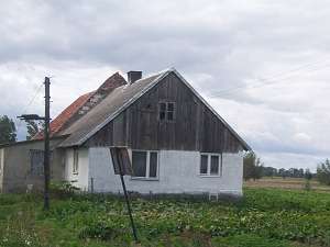 No. 9 is a longitudinal
Dutch homestead situated in the central section of the village, by an
intersection, on the western side of the road to Krzewsk, facing it with
its gable. A house is separated from a cowshed by a fire wall. A barn has
been demolished. The house dates from the 3rd quarter of the 19th century
and has a brick underpinning, a plastered log structure with planking, and
a rafter - collar beam roof structure covered by asbestos tiles. The gable
elevation has 2 axes with a small window in the gable. The southern
elevation has 3 axes and an entrance with a modern extension in the 2nd
axis. No. 9 is a longitudinal
Dutch homestead situated in the central section of the village, by an
intersection, on the western side of the road to Krzewsk, facing it with
its gable. A house is separated from a cowshed by a fire wall. A barn has
been demolished. The house dates from the 3rd quarter of the 19th century
and has a brick underpinning, a plastered log structure with planking, and
a rafter - collar beam roof structure covered by asbestos tiles. The gable
elevation has 2 axes with a small window in the gable. The southern
elevation has 3 axes and an entrance with a modern extension in the 2nd
axis.
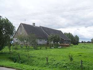 No. 56 is a longitudinal Dutch homestead situated in the
central section of the village, on the western side of the road to
Krzewsk, facing it with its gable. The farming section is higher. The
house dates from the 3rd quarter of the 19th century and has a brick
underpinning, a plastered log structure, a boarded gable, a rafter -
collar beam roof structure, and asbestos tile roofing. The eastern
elevation has 2 axes and a 3-axial gable with a window enclosed by
rhomboidal skylights topped by segmented arches. The southern elevation
has 4 axes with an entrance in the 2nd axis from the west. No. 56 is a longitudinal Dutch homestead situated in the
central section of the village, on the western side of the road to
Krzewsk, facing it with its gable. The farming section is higher. The
house dates from the 3rd quarter of the 19th century and has a brick
underpinning, a plastered log structure, a boarded gable, a rafter -
collar beam roof structure, and asbestos tile roofing. The eastern
elevation has 2 axes and a 3-axial gable with a window enclosed by
rhomboidal skylights topped by segmented arches. The southern elevation
has 4 axes with an entrance in the 2nd axis from the west.
SGKP, t.X, s.297; AG IV;BF; Lipińska, t. III, poz. 138
|
)