|
gm. Dragacz, pow. świecki, woj. kujawsko-pomorskie
The earliest mention of the settlement dates back to the 15th century. In 1410 the village belonged to estates giving 1 armed horse service. In 1433 Jeschke von Michelau donated to his wife 400 grzywnas as a life income, paying her 30 grzywnas yearly. Around 1434 we know about Tymo von Michelaw. In 1454 great master Ludwik von Erlichshausen gives to Maciej von der Kirchturau half of the village.
In the second half of the 16th the settlement is described as an agricultural village, gentry property in the Świecie poviat. The Dutch settled in the village before 1565, overtaking the Catholic church in the village, among others. (...They came [the inhabitants of Bratwin] to Michalia but Olęders had already destroyed the church, and they kept cattle in it. It would be better if the church remained Catholic...) Michale was a single-village parish. From the sixties of the 16th century the church was in the hands of Olęders and in 1686 on place of the temple only a cross remained.
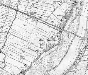
In the Prussian partition the village entered in the Świecie poviat of the Kwidzyń District. It included also the manor belonging to the estate in Grupa. Michale was part of the Sartowice Catholic parish and the Górna Grupa Evangelic parish. The manor possessed 208ha, 12 buildings, 5 houses, 6 inhabitants (5 Evangelists and 1 Catholic). The village owned 3082 morgas, 86 buildings, 59 houses, 498 inhabitants (32 Catholic and 457 Evangelists). A linear village, the so-called riverfront village (rzędówka bagienna) situated on the Vistula, in the north-eastern part of the Świecie poviat. The main road runs along the embankment, following the north-east - south line.
Historic monuments in the village: a manor building, a smithy and 4 wooden houses related to the Olęder colonisation.
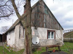
 No. 9 - house built in the third quarter of the 19th century, with its ridge facing a dirt road leading from Michale to Górna Grupa; located in the north-western part of the village, housing the farm and residential section lined-up under one roof.
The building is on the plan of a rectangle, double-bay with a hallway in the southern bay. Kitchen in the northern part. Entrance door in the southern elevation. Single-floor, with a cellar under part of it. Covered with a double-pitched roof. The loft is usable. The northern elevation is five-axial, unsymmetrical. The southern elevation is four-axial, unsymmetrical with a porch on the western side. The eastern elevation is connected with the farm section. The western elevation is tri-axial, unsymmetrical.
The house rests on a brick and stone plinth, is made of wood and has a corner-notched structure. Plastered. Brick, bottle-shaped chimney. Wooden floors, beam ceilings. The gables are planked. Collar beam roof truss with king posts. Roof covered with fish-scale pantiles. Porch haa a timber-frame structure. Wooden, double-cased, two-level windows in window-frames. Wooden, single- and double-leaf doors having frame and panel structure. Simple wooden straight-flight staircase.
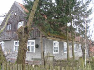
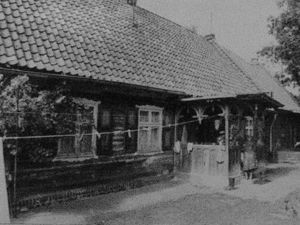 No. 65 - house built w 1893 r., with its ridge facing a road running along the embankment; located in the north-western part of the village, housing the farm and residential section lined-up under one roof.
The building is on the plan of a rectangle, double-bay with a hallway in the eastern bay. The so-called \'black kitchen\' has been preserved. Entrance doors in the southern and eastern elevations. Single-floor, with a cellar under part of it. Covered with a double-pitched roof. The loft is usable. The northern elevation connected with the farm section. The southern elevation is bi-axial, symmetrical. The eastern elevation is eight-axial, unsymmetrical with a porch covered with a double-pitched roof. The western elevation is seven-axial, unsymmetrical. In the lintel an inscription has survived "K. L. Luske B.M. 1839"
The house rests on a brick and stone plinth, is made of wood and has a corner-notched structure. The farm section is made of brick. Brick, bottle-shaped chimney. Wooden floors, in the hallway and in the kitchen cement floors. Ceilings made of ceiling joists with bevelled edges, panels between them are ceiled with board. The gables are planked. Collar beam roof truss with king posts. The roof is covered with pantiles. The porch has a timber-frame structure. Wooden, double-cased, two-level windows in window-frames. Wooden, single- and double-leaved doors having a frame and panel structure. Wooden, straight-flight, quarter landing staircase.
Documents on which the study was based: Michale 65, Historic Monuments of Architecture and Construction Registry Card, elaborated by I. Jastrzębska-Puzowska, E. Sekuła-Tauer, K. Bartowski, typescript, Bydgoszcz 1993; Katalog zabytków województwa bydgoskiego, elaborated by K. Parucka, E. Raczyńska-M±kowska, Bydgoszcz 1997, p. 56; Zabytki architektury i budownictwa w Polsce. Województwo Bydgoskie, opr. K. Parucka vol. 5, Warszawa 1997, part 2, p. 287.
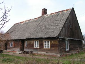 No. 68 - house built in the 1st quarter of the 19th century, with its gable facing a road running along the embankment; located in the north-western part of the village, housing the farm and residential section lined-up under one roof.
The building is on the plan of a rectangle, double-bay with a hallway in the southern bay. Kitchen in the northern part. At the eastern side of the hallway a \'black kitchen\' has been preserved. Entrance door in the southern elevation. Single-floor, with a cellar under part of it. Covered with a double-pitched roof. The loft is usable. The northern elevation is tri-axial, unsymmetrical. The southern elevation is seven-axial, unsymmetrical. The eastern elevation is bi-axial, unsymmetrical. The western elevation is single-axial, unsymmetrical.
The house rests on a brick and stone plinth, is made of wood and has a corner-notched structure. Brick, bottle-shaped chimney. Wooden floors, beam ceiling. The gables are planked. Collar beam roof truss. The roof is covered with asbestos cement. Wooden, double-cased windows in window-frames and one-case plastic windows. Wooden, single-leaf doors having frame and panel structure and board and slat structure. Simple wooden straight-flight staircase.
 No. 69 - house built c.a. mid-19th century, with its ridge facing a road running along the embankment; situated in the north-western part of the village. House not connected with farm buildings. The homestead has a dispersed layout.
The building is on the plan of a rectangle, double-bay with a passage hallway. Kitchen in the eastern part. Entrance doors in the eastern and western elevations. Single-floor, with a cellar under part of it. Covered with a double-pitched roof. The loft is usable. The northern and southern elevations are bi-axial, unsymmetrical. The eastern elevation is tri-axial, unsymmetrical. The western elevation is bi-axial, unsymmetrical.
The house rests on a brick and stone plinth, is made of wood and has a corner-notched structure. Plastered. Brick, bottle-shaped chimney. Cement floors, beam ceilings ceiled with board. The gables are planked. Collar beam roof truss. The roof is covered with asbestos cement. Wooden, double-cased box windows. Board, single-leaf doors. Simple wooden straight-flight staircase.
Documents on which the study was based: Zabytki architektury i budownictwa w Polsce. Województwo Bydgoskie, opr. K. Parucka vol. 5, Warszawa 1997, part 2, p. 85.
No. 133 - house built c.a. mid-19th century (?), with its ridge facing a road running along the embankment; located in the southwestern part of the village, not connected with farm buildings. The homestead has a dispersed layout.
The building is on the plan of a rectangle, double-bay with a hallway in the eastern bay. Kitchen in the western part. Entrance door in the eastern elevation. Single-floor, with a cellar under part of it. Covered with a double-pitched roof. The loft is usable. An annex adjoins the northern elevation. The southern elevation is bi-axial, symmetrical. The eastern and western elevations are tri-axial, unsymmetrical.
The house rests on a brick and stone plinth, is made of wood and has a corner-notched structure. Brick, bottle-shaped chimney. Wooden floors. Cement floors in the kitchen and in the hallway. Beam ceiling, panels between beams ceiled with board. The gables are planked. Collar beam roof truss. Roof covered with roofing paper. Wooden, double-cased windows in window-frames. Wooden, single-leaf, planked doors having frame and panel structure. Simple wooden straight-flight staircase.
Documents on which the study was based: Zabytki architektury i budownictwa w Polsce. Województwo Bydgoskie, opr. K. Parucka vol. 5, Warszawa 1997, part 2, p. 85.
SGKP, t. 6, Warszawa 1885, s. 294; H. Maercker, Eine polnische Starostei und ein preussischer Landrathkreis. Geschichte des Schwetzer Kreises 1466-1873, "Zeitschrift des Westpreussischen Geschichtvereins", H. 17-19, Danzig 1886-1888, s. 263-264; Visitationes Archidiaconatus Pomeraniae 1583, wyd. S. Kujot, TNT, Fontes 1-3, Toruni 1897, s. 94, 148, 249; Biskup M., Tomczak A., Mapy województwa pomorskiego w drugiej połowie XVI w., Rocznik TNT, R. 58, 1955, z. 1, s. 128; K. Ciesielska,, Osadnictwo "olęderskie" w Prusach Królewskich na Kujawach w świetle kontraktów osadniczych, "Studia i Materiały z dziejów Wielkopolski i Pomorza", t. 4, 1958, s. 223; K. Mikulski, Osadnictwo wiejskie woj. Pomorskiego od poł XVI do końca XVII wieku, Rocznik TNT, R. 86, Toruń 1994, z. 2, s. 174; Katalog zabytków województwa bydgoskiego, oprac. K. Parucka, E. Raczyńska-Mąkowska, Bydgoszcz 1997, s. 55.SGKP, t. 6, Warszawa 1885, s. 294; H. Maercker, Eine polnische Starostei und ein preussischer Landrathkreis. Geschichte des Schwetzer Kreises 1466-1873, "Zeitschrift des Westpreussischen Geschichtvereins", H. 17-19, Danzig 1886-1888, s. 263-264; Visitationes Archidiaconatus Pomeraniae 1583, wyd. S. Kujot, TNT, Fontes 1-3, Toruni 1897, s. 94, 148, 249; Biskup M., Tomczak A., Mapy województwa pomorskiego w drugiej połowie XVI w., Rocznik TNT, R. 58, 1955, z. 1, s. 128; K. Ciesielska,, Osadnictwo "olęderskie" w Prusach Królewskich na Kujawach w świetle kontraktów osadniczych, "Studia i Materiały z dziejów Wielkopolski i Pomorza", t. 4, 1958, s. 223; K. Mikulski, Osadnictwo wiejskie woj. Pomorskiego od poł XVI do końca XVII wieku, Rocznik TNT, R. 86, Toruń 1994, z. 2, s. 174; Katalog zabytków województwa bydgoskiego, oprac. K. Parucka, E. Raczyńska-Mąkowska, Bydgoszcz 1997, s. 55.
|