|
gm. Sadlinki, pow. kwidzyński, woj. pomorskie
(Do 1945 roku Sedlinen)
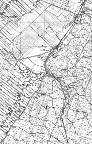
In the early medieval times, there was a castle here. In 1346, it was a bishop's property. Probably, there was a manor here, which was the centre of the economic administration of the adjacent bishop's properties (destroyed in the 15th century). After secularization, the village belonged to the gentry. In 1539, the properties were owned by Paweł Separat, a Lutheran who still called himself the Pomezanian bishop. In 1558, the contract is granted to Feliks Zaschin who had a privilege on Sadlinki from 1550. In 1543, the village counted 218.4 ha of land, in 1558, 336 ha. At the end of the 16th century, the village was owned by the Rębowski - Sabiński family. Then by Jan Groeben, a courtier of king Jan Kazimierz. A mention of Mennonites settled in the place called Klein Sedlinen comes from 1584. In 1686, the manor farm counted 151 ha of land, while farmers had 504 ha of land. In 1787, the population counted 193 inhabitants. In the 18th century, the village belonged to the Marwicz family. In 1885, captain Charles de Beaulieu was the squire. In 1910, the area amounted to 516 ha with 190 inhabitants. Tobacco growing was popular in this area. In the beginning of the 20th century, the seat of Westpreussischen Tabakengenossenschaft was located here. In the 19th century, an evangelical school, a military policy station and 3 inns were built here. In 1928, Stare Młynki-Ruda was merged with Sadlinki into one commune. Seasonal workers employed in tobacco plantations worked in Arthur Utesch's brickyard in the winter time. A village composed of hamlets arranged in rows and colonies, situated on the right bank of the Vistula, in the southern part of the Kwidzyn lowlands, about 6 km south of Kwidzyn. The cultural landscape preserved in a poor condition. The village has been significantly changed because of the strong development of settlement on the turn of the 19th century.
SGKP, t.10, ss. 199-200; R. Flans, Das ehemalige Amt Marienwerder, insonderheit die Amts-Niederung, „Zeitschrift des Historischen Vereins für Reg.-Bez. Marienwerder“ H. 34, 1896, s.68; R. Flans, Das ehemalige Amt Marienwerder, insonderheit die Amts-Niederung, „Zeitschrift des Historischen Vereins für Reg.-Bez. Marienwerder“ H. 35, 1897, s. 57; M. Kerner-Żuralska, Materiały do dziejów osadnictwa Pomezanii, „Komunikaty Mazursko-Warmińskie”, nr 2, 1964, s. 159; A. Lemański, W. Odyniec, J. Powierski, Dzieje wsi [w:] Kwidzyn. Z dziejów miasta i okolic, Olsztyn 1982, ss. 286-287.
Strony internetowe: http://kwidzynopedia.pl/index.php/Sadlinki, 05.08.2009.
|
)