|
gm. Wartkowice, pow. poddębicki, woj. łódzkie
(Hol. Kickie - Mapa Kwatermistrzostwa – 1830, , Kiki - Mapa Chrzanowskiego - 1848)
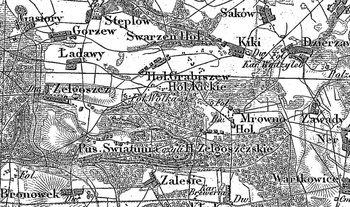
Former village and gentry grange (owned by Józef and Julian Gnoińscy), situated in the former Łask poviat, Bałucz commune, Mikołajewice parish. In 1827 it had 10 houses and 82 inhabitants. In 1880 it counted 185 inhabitants, 61 morgas of peasant land and 593 of noble land. The Hollanders were settled there in 1791. Small, linear village situated latitudinally, with the majority of homesteads located on the northern side of the road. Landscape related to the Dutch colonisation transformed, illegible. Lack of material traces of colonists.
SGKP, T. IV, Warszawa 1883, s. 95, J. Goldberg, Osadnictwo...
|
)