POLISH VERSION


Home | Introduction | Download e-book | Conference 2001 | Special thanks | The note of law | Contact
Articles: Poland | Małopolska | Mazowsze | Ziemia Łęczycka | Żuławy | Nizina Sartowicko-Nowska | Ziemia Kwidzyńska | Ziemia Walichnowska | Ziemia Sieradzka | Ziemia Wieluńska
Dutch villages --> Ziemia Sieradzka
Krzykosy
Następna miejscowo¶ć Next village
Explanations
Map of district

gm. D±bie, pow. kolski, woj. wielkopolskie

(Hol. Borek - Mapa Kwatermistrzostwa – 1830, , Gaj - Mapa Chrzanowskiego - 1848)

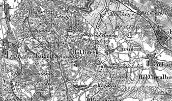
Village settled by the Hollander colonists at the end of the 18th century.

Colonial village situated west of D±bie, with few homesteads dispersed among the fields.

Traditional landscape related to the Dutch colonisation legible. Visible traces of land drainage carried out by the colonists – dewatering ditches and artificial planting of trees and shrubbery (especially on balks). The development characteristic for the colonisation under the Dutch law has not been preserved.


Home | Introduction | Download e-book | Conference 2001 | Special thanks | The note of law | Contact
Articles: Poland | Małopolska | Mazowsze | Ziemia Łęczycka | Żuławy | Nizina Sartowicko-Nowska | Ziemia Kwidzyńska | Ziemia Walichnowska | Ziemia Sieradzka | Ziemia Wieluńska

Copyright 2005 © jerzyszalygin@wp.pl