|
gm. Pabianice, pow. pabianicki, woj. łódzkie
(Kol. Pawlikowice - Mapa Kwatermistrzostwa – 1830, , Pawliczkowice - Mapa Chrzanowskiego - 1848)
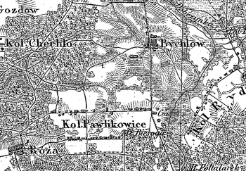
Former Church-owned village (Kraków Charter) in the former Łask poviat, Góra Pabiańska commune, Pabianice parish. In 1827 it had 56 houses and 401 inhabitants. It belonged to the Widzów estate. In 1886 it had 59 houses and 515 inhabitants. The Hollanders were settled there around 1790. Large linear (on the west) and single-street (on the east) village, located south of Pabianice, stretching longitudinally with development on both sides of the road. Houses mainly have the character of suburban villas. Traditional landscape related to the Dutch colonisation transformed, illegible. Lack of material traces of colonists.
SGKP, T. VII, Warszawa 1886, s. 902.
Łaski, II, 415.
J. Goldberg, Osadnictwo...
|
)