|
gm. Zapolice, pow. zduńskowolski, woj. łódzkie
(Hol. Ptaszkowskie - Mapa Kwatermistrzostwa – 1830, Rojkow Hol. - Mapa Chrzanowskiego - 1848)
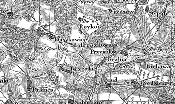
Former village, colony and gentry grange (owned by Wojciech Rawicz Noskowski), located by the Wolborka river in the former Łask poviat, Zapolice commune and Marzenin parish. In 1888 the village had 7 houses, 45 inhabitants and 63 morgas of surface, the colony – 8 houses, 53 inhabitants and 119 morgas of surface, and the grange – 3 houses, 54 inhabitants and 240 morgas of surface (158 morgas of arable land and gardens, 18 morgas of meadows, 52 morgas of pastures, 12 morgas of wasteland, 5 brick and 6 wooden buildings). The Hollanders were settled there in 1792. Medium size village located south of Zduńska Wola. Linear and colonial, with development situated mainly on the eastern side of the road. Traditional landscape related to the Dutch colonisation transformed, illegible. Lack of material traces of colonists.
SGKP, T. IX, Warszawa 1888, s. 700.
Łaski, I, 483.
|
)