|
gm. Uniejów, pow. poddębicki, woj. łódzkie
(Rożniatów - Mapa Kwatermistrzostwa – 1830, - Mapa Chrzanowskiego - 1848)
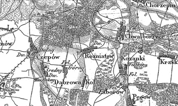
Former gentry village and grange (owned by Rupert Dunin), located in the former Turek poviat, Kotniki commune, Zielenin parish. In 1887 it had 8 houses and 166 inhabitants; the grange, having the surface of 685 morgas, counted 6 houses and 90 inhabitants. The Hollanders were settled in the vicinity of the village in 1789. Medium size, linear village with development on both sides of the road running latitudinally. Houses modern, situated mainly with their ridge to the road. Traditional landscape related to the Dutch colonisation transformed, illegible. Lack of material traces of colonists.
SGKP, T. IX, Warszawa 1888, s. 864, J. Goldberg, Osadnictwo...
Łaski, II, 415.
|
)