POLISH VERSION


Home | Introduction | Download e-book | Conference 2001 | Special thanks | The note of law | Contact
Articles: Poland | Małopolska | Mazowsze | Ziemia Łęczycka | Żuławy | Nizina Sartowicko-Nowska | Ziemia Kwidzyńska | Ziemia Walichnowska | Ziemia Sieradzka | Ziemia Wieluńska
Dutch villages --> Ziemia Sieradzka
Zagaj
Następna miejscowość Next village
Explanations
Map of district

gm. Dobra, pow. turecki, woj. wielkopolskie

(Hol. Kaczka - Mapa Kwatermistrzostwa – 1830, Gozdy - Mapa Chrzanowskiego - 1848)

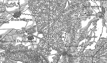
Former colony in the Turek poviat, Piekary commune, Skęczniew parish. In 1895 it had 8 houses. It was settled by the Hollander colonists at the beginning of the 19th century.

Small linear village situated longitudinally, west of the Warta river, with the majority of homesteads located on the western side of the road.

Landscape related to the Dutch colonisation transformed, illegible. Lack of material traces of colonists.

    
SGKP, T. XIV, Warszawa 1895, s. 257.


Home | Introduction | Download e-book | Conference 2001 | Special thanks | The note of law | Contact
Articles: Poland | Małopolska | Mazowsze | Ziemia Łęczycka | Żuławy | Nizina Sartowicko-Nowska | Ziemia Kwidzyńska | Ziemia Walichnowska | Ziemia Sieradzka | Ziemia Wieluńska

Copyright 2005 © jerzyszalygin@wp.pl