|
gm. Warszawa-Wilanów, pow. warszawski, woj. mazowieckie
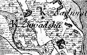
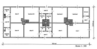
Originally, Kępa Zawadowska was a linear village (49 morga), which was founded in order put under cultivation the riverside wastelands that belonged to the Wilanowski Potocki estate. The first (not preserved in the archival records) contracts were signed in 1819 and 1823. The next emphyteutic contract, which has survived to the present day, was concluded on November 24, 1824 for 40 years, with a possibility of extension. The colonists were to pay 15 złoty rent per each morga of cultivated land (the settlers were able to enlarge the area of the arable land by clearing bushes growing within the settlement's limits). The first settlements were founded on the side of the village of Zawada and manor fields. The contract between the landowner and the settlers was officially concluded on June 22, 1832. According to its provisions the settlers undertook to "erect buildings necessary to work the adjoining land; the buildings are to be erected in suitable sites at the colonists' cost within four years . For each włóka, settlers are to build a home that is 24 ells long and 14 ells wide from timber, and a barn for straw that is 20 ells long and 11 ells wide from planks". In 1827, the village had 7 houses and 64 residents.
In 1832, the colonists erected a school and a chapel, established a cemetery, and built additional houses. Due to the high quality of the soil, the farms produced grain and vegetables (potatoes) almost exclusively. In spite of numerous obligations towards the manor, majority of the farms were thriving - also due to the flooding. After the 1844 flooding, the settlers began to build flood-banks; the works were completed, not without problems, in 1860. In 1905, the village had 35 houses, and 278 residents.
The colonists remained in the area near Warsaw until 1944, and at that time they were evacuated to Germany in face of the approaching Red Army's offensive. In 1951, the village was incorporated into the city of Warsaw.
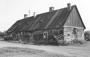 No buildings associated with this colonization have survived to the present day. The last building was taken down in 1998 (see: the photo and the ground view). However, despite the village urbanization and its inclusion in Warsaw in 1951, the remains of the cultural landscape related to the Dutch colonization are still detectable. Most of all, still visible are: planted willows and poplars, field layout, sections of the old flood-bank, and also a cemetery, which is located in the western part of the village. No buildings associated with this colonization have survived to the present day. The last building was taken down in 1998 (see: the photo and the ground view). However, despite the village urbanization and its inclusion in Warsaw in 1951, the remains of the cultural landscape related to the Dutch colonization are still detectable. Most of all, still visible are: planted willows and poplars, field layout, sections of the old flood-bank, and also a cemetery, which is located in the western part of the village.
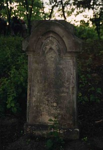
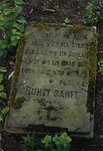
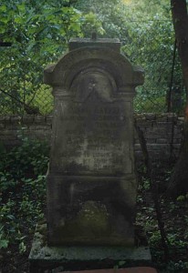
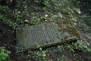 The cemetery was established on the rectangular plan and currently is located on the southern side of Syta street. The cemetery is situated on the man-made rise and is fenced with a metal fence on a brick foundation. After being destroyed, the cemetery was cleaned up in 2000. Five gravestones from the 20th century have remained. The rest of them are damaged to such degree that their identification is impossible. The cemetery was established on the rectangular plan and currently is located on the southern side of Syta street. The cemetery is situated on the man-made rise and is fenced with a metal fence on a brick foundation. After being destroyed, the cemetery was cleaned up in 2000. Five gravestones from the 20th century have remained. The rest of them are damaged to such degree that their identification is impossible.
J. Kazimierczak, Kępa Zawadowska - wieś olendrów w granicach Warszawy (1819-1944), "Rocznik Warszawski", t. V, 1964, s. 235-256;
SGKP, t. III, 1882, s. 955;
J. Szałygin, "Olędrzy" w Warszawie, "Mazowsze", 2001, nr 14, s. 39-50.
|
)
)