|
gm. Brochów, pow. sochaczewski, woj. mazowieckie
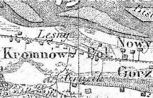
A Dutch settlement existed in the older royal village of Kromnów. It was founded at the end of the 18th century on the church land in the northern section of Kromnów. At that time, the village had to names which distinguished the ethnicity of the residents living in two sections of the village: Kromnów Polski and Kromnów Niemiecki. In 1827, Kromnów Polski had 23 houses and 251 residents, while Kromnów Niemiecki 3 houses and 22 residents.
Kromnów is a linear village located on the southern side of the Kazuń-Śladów road. The cultural landscape of the Dutch settlement located on the northern side of the road is detectable with a preserved field layout, artificial rises, and drainage canals. The traditional settlements were destroyed after WWII. The southern section - Kromnów Polski - has been transformed; the buildings are modern.
SGKP, t. IV, 1883, s. 694.
|
)